
Manaslu Circuit Trek Map: A Complete Guide to Navigating Nepal's Hidden Gem
The Manaslu Circuit Trek is a breathtaking journey through Nepal's remote and pristine landscapes, offering trekkers a unique blend of cultural immersion and natural beauty. With its rugged trails, traditional villages, and stunning views of the eighth-highest mountain in the world, Mount Manaslu (8,163 meters), this trek is gaining popularity among adventure enthusiasts. Understanding the Manaslu Circuit Trek map is crucial for planning and making the most of your experience. In this guide, we’ll break down the trek itinerary, route highlights, and essential tips.
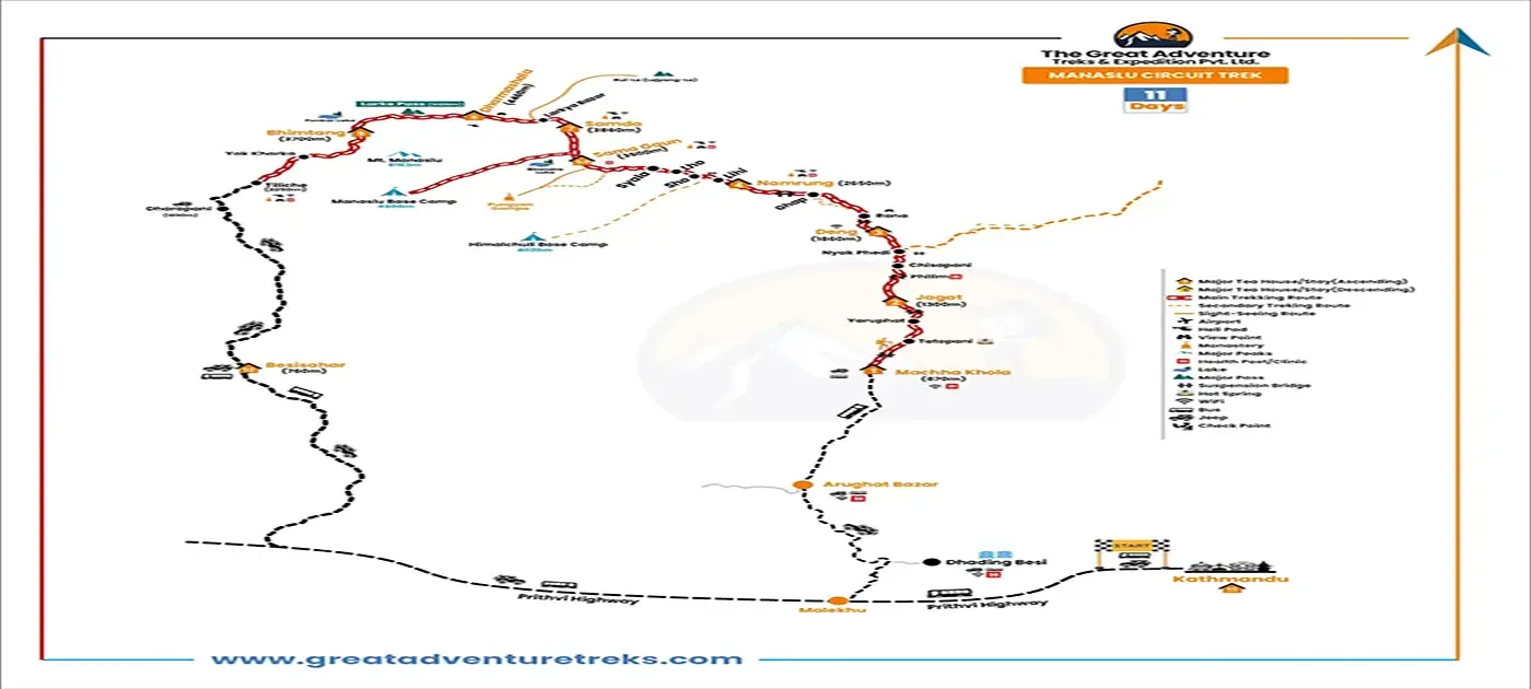
 manaslu-circuit-trek-11-days
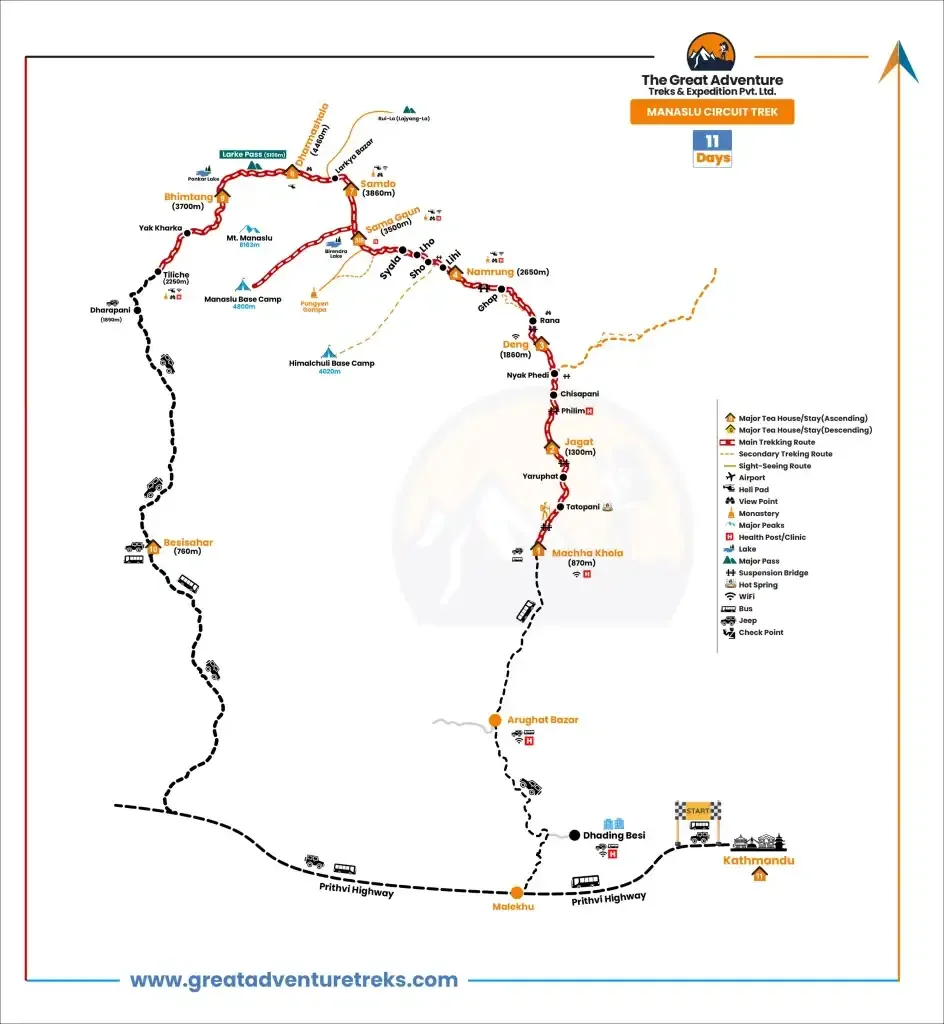
manaslu-circuit-trek-11-days-Trekking Map
Outline Itinerary of the Manaslu Circuit Trek
Day 01: Drive from Kathmandu to Machha Khola
- Elevation: 870 m (2854 ft)
- Distance: 160 km (99.4 mi)
- Duration: 10 – 12 hours
- Accommodation: Tea HouseThe journey begins with a scenic drive from Kathmandu to Machha Khola, passing through hills, rivers, and terraced fields.
Day 02: Trek from Machha Khola to Jagat
- Elevation: 1300 m (4265 ft)
- Distance: 22 km (13.7 mi)
- Duration: 7 – 8 hours
- Accommodation: Tea HouseThis section involves crossing suspension bridges and navigating narrow trails alongside the Budhi Gandaki River.
Day 03: Trek from Jagat to Deng
- Elevation: 1860 m (6102 ft)
- Distance: 20 km (12.4 mi)
- Duration: 6 – 7 hours
- Accommodation: Tea HouseThe trail ascends through lush forests and picturesque villages, offering glimpses of Tibetan culture.
Day 04: Trek from Deng to Namrung
- Elevation: 2660 m (8727 ft)
- Distance: 19.5 km (12.1 mi)
- Duration: 6 – 7 hours
- Accommodation: Tea HouseTrekkers pass through rhododendron forests and encounter breathtaking views of Ganesh Himal.
Day 05: Trek to Sama Gaun via Pungyen Gompa
- Elevation: 3500 m (11482 ft) via Pungyen Gompa (3530 m / 11578 ft)
- Distance: 10 km (6.2 mi)
- Duration: 5 – 6 hours
- Accommodation: Tea HouseThis day features a visit to the serene Pungyen Gompa and the traditional village of Sama Gaun.
Day 06: Rest Day at Sama Gaun and Visit Manaslu Base Camp
- Elevation: 4800 m (15,748 ft)
- Distance: 5.1 km (3.16 mi)
- Duration: 6 – 7 hours
- Accommodation: Tea HouseA crucial acclimatization day, trekkers can hike to Manaslu Base Camp for spectacular views.
Day 07: Trek from Sama Gaun to Samdo
- Elevation: 3860 m (12,661 ft)
- Distance: 5.1 km (3.16 mi)
- Duration: 4 – 5 hours
- Accommodation: Tea HouseThe trail leads to Samdo, the last settlement before Larkya La Pass, with stunning mountain vistas.
Day 08: Trek from Samdo to Dharamsala (Larkya Base Camp)
- Elevation: 4460 m (14,632 ft)
- Distance: 11.7 km (7.2 mi)
- Duration: 4 – 5 hours
- Accommodation: Tea HouseThis section offers mesmerizing views of snow-capped peaks as trekkers prepare for the pass crossing.
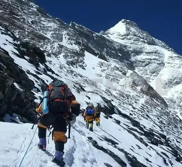
Day 09: Trek from Dharamsala to Bhimtang via Larkya La Pass
- Elevation: Larkya La Pass (5106 m / 16751 ft), Bhimtang (3590 m / 11776 ft)
- Distance: 24 km (14.9 mi)
- Duration: 8 – 9 hours
- Accommodation: Tea HouseThe most challenging day, crossing the Larkya La Pass rewards trekkers with panoramic views of Himlung Himal, Cheo Himal, and Lamjung Himal.
Day 10: Trek from Bhimtang to Tilije and Drive to Besishar
- Elevation: Tilije (1860 m / 6102 ft), Besishar (825 m / 2706 ft)
- Distance: 8 km (4.9 mi)
- Duration: 4 – 5 hours (trek), local Jeep drive
- Accommodation: Guest HouseThe trek descends through forests and villages before driving to Besishar.
Day 11: Drive from Besishar to Kathmandu
- Elevation: Kathmandu (1400 m / 4593 ft)
- Distance: 175 km (108.9 mi)
- Duration: 6 – 7 hours
- Accommodation: HotelA comfortable drive back to Kathmandu marks the end of the trek.
Navigating the Manaslu Circuit Trek Map
The outlined itinerary aligns with the detailed trek map, guiding you through every stage of this awe-inspiring journey. Physical maps and digital tools like GPS devices and trekking apps can enhance your navigation.
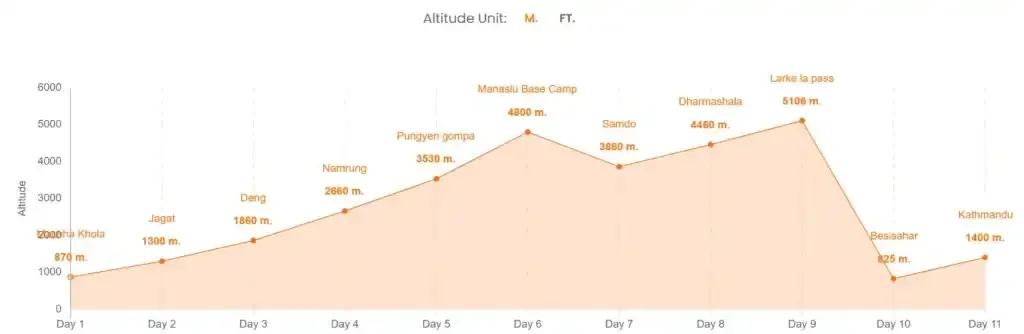
Manaslu Circuit Trek Altitude Chart:
Tips for a Successful Trek
- Hire a Guide: Required for permits and safety in restricted areas.
- Acclimatize: Follow the itinerary to ensure proper acclimatization.
- Weather Awareness: Be prepared for changing conditions, especially at higher altitudes.
- Permits: Secure the Manaslu Conservation Area Permit, Annapurna Conservation Area Permit, and Restricted Area Permit.